Fig 1
(Click on the figure to get a bigger version)
Lakes respond in a simple and well-understood fashion to changes in the balance of precipitation and evaporation (P-E) over the lake and catchment by changing in volume (and hence, monotonically, in area and level). In overflowing lakes in humid regions, runoff from the catchment primarily determines the equilibrium lake level and hence the magnitude of lake discharge. Sustained changes in lake discharge are only produced when lake volume is also changed (Cheddadi et al., 1997). In closed lakes in semi-arid regions, the area of the lake represents an equilibrium between run-off from the catchment and the water deficit over the lake (Street- Perrott and Harrison, 1985). Long-term changes in lake level, area and depth (collectively referred to as lake status) affect the physical and biological conditions in a lake and so can be reconstructed from geomorphic or biostratigraphic records (Street-Perrott and Harrison, 1985; Harrison and Digerfeldt, 1993). Although changes in lakes can be caused by local, non-climatic factors, regionally synchronous changes are reasonably assumed to be a direct reflection of regional P-E changes. Semi-quantitative estimates of lake status at key times can be directly compared to simulated P-E fields, in order to determine whether the sign and the spatial patterns of simulated P-E anomalies are realistic.
The Global Lake Status Data Base (GLSDB: Kohfeld and Harrison, 2000, Harrison et al., 2003) is a long-standing international effort to compile the geomorphic and biostratigraphic data for changes in lake status, in order to document changes in regional water balance during the last 30,000 14C kyr. Developed with data-model comparisons as a primary objective, the GLSDB contains data both from closed-basin lakes in now-arid regions and from currently overflowing lakes in temperate and wet tropical regions. The GLSDB contains continuous records of lake status through time, so that site chronologies can be modifed and data extracted for any time interval required. Here, we present the data for the mid-Holocene (6000 yr B.P. on the radiocarbon time scale) and the last glacial maximum defined as 18,000 yr B.P. on the radiocarbon time scale, equivalent to 21,000 yr B.P. on the calendar time scale) derived from Kohfeld and Harrison (2000) and including updates published in Yu et al. (2001) and Harrison et al. (2003).
Fig 1
(Click on the figure to get a bigger version)
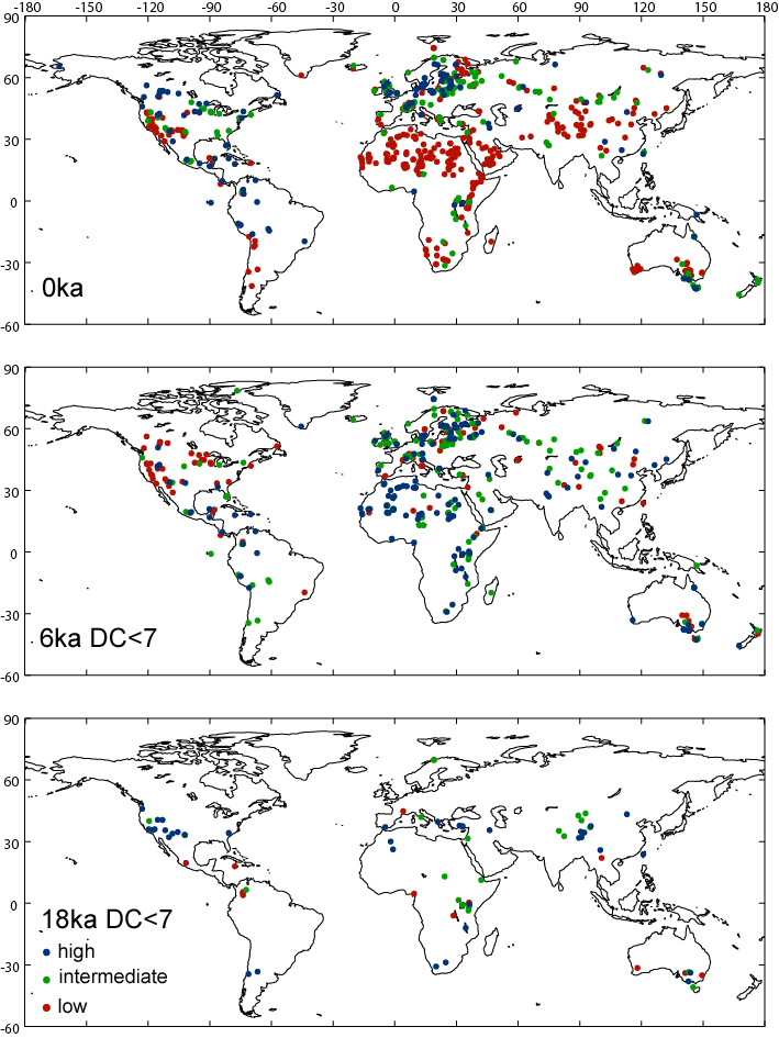
The lake status data are commonly presented as differences from today.

Fig 2
(Click on the figure to get a bigger version)
The current version of the GLSDB (Version 2) has records for 599 modern sites, 413 sites at 6000 yr B.P., and 103 sites at 18,000 yr B.P. Please note: the data sets contain information about the quality of the dating control at each time period (DC6 = dating control at 6000 yr B.P., DC18 = dating control at the last glacial maximum) using the COHMAP dating control schemes, as described in Yu and Harrison (1995). We stongly recommend that you only use sites with a dating control <7 in making data-model comparisons at 6000 yr B.P. and <7 in making data-model comparisons at 18,000 yr B.P. (as is done in the maps shown above). Sites with no explicit dating control should be included. If you do this, you should have 599 modern sites, 394 6000 yr B.P. sites, 70 18,000 yr B.P. sites.
If you wish to use the global data set, you should cite Kohfeld and Harrison (2000), Yu et al. (2001) and Harrison et al. (2003) as the sources of the original data. If you wish to have lake status maps for other time periods in the last 30,000 years, you should contact Sandy Harrison directly.
Technical queries about the data sets should be addressed to Sandy Harrison or Mark Creighton. The GLSDB has received funding support from IGBP-GAIM, IGBP-PAGES, IGBP-DIS, the U.S. Department of Energy, the U.S. National Science Foundation, the NOAA Climate and Global Change Program, the European Community, the Royal Swedish Academy of Sciences, the Swedish Natural Science Research Council (NFR), the Swedish Institute, Crafoord Fund, and the Max-Planck Institute for Biogeochemistry.